The Orange River
- S Liefferink & R Tate

- Apr 11, 2025
- 5 min read
Updated: Jan 8

The Orange River is the largest river system in South Africa with a watershed approximate to 984 867 km2. Rising in the highlands of Lesotho, the Orange River is shared between four countries including Botswana, Lesotho, Namibia and South Africa.

The Headwaters
The headwaters of the Orange River occur primarily in the Lesotho Highlands which we unfortunately have not yet visited. This post will illustrate other headwater systems of the Orange River.
The Bell, Bokspruit and Kraai Rivers

The Bell River, a major tributary of the Kraai River has a source near Naude's Nek Pass and the Tiffindell Ski Resort, considered one of the highest elevations in South Africa. These high elevation watercourses consist of source zone depression and seep wetland systems. These in-turn feed downslope seep, channeled and unchanneled valley bottom wetlands.


The combination of extensive wetlands, high elevations, and yearly snowfall has given rise to a distinctive flora with specialized adaptations to these unique conditions. The flora must be able to withstand cold winters and annual snowfall.
The wetland areas transition into swiftly flowing rivers controlled by bedrock and surrounded by seeping foot-slope wetlands. These habitats are characterized by waterfalls, cascades, shallow rivers with small pools, and generally fast-flowing crystal clear water over bedrock.


At lower elevations in the upper foothills, water gathers into larger rivers, flows with increased stream power scouring all but boulders and large cobbles forming scoured pools connected by shallow runs and riffles in deeply incised or weathered valley bottoms. These high energy systems flatten, flood, meander and widen the valleys and to create rich fertile interconnected floodplain wetlands.


The dense marginal vegetation of the channel edge in the swiftly flowing rivers creates the ideal habitat for species adapted to high elevations like Chlorolestes fasciatus (bottom right) and the endemic Psuedagrion draconis (bottom left). The floodplain margins are rich in colourful flora like and many Lobelia species.


At these higher elevations indigenous fish fauna is almost entirely composed of Enteromius oraniensis, a beautiful golden soft-rayed species recently separated from Enteromius anoplus. This region is also famous for the wild populations of Oncorhynchus mykiss (Rainbow Trout) with fly fishing anglers from all over the country chasing this species through initiatives like the Wild Trout Association (Wildtrout.co.za) who facilitate access to these beautiful streams and rivers.
At lower elevations, particularly within the lower reaches of the Bokspruit and upper reaches of the Kraai River, annual summer migrations of the Orange River endemic Labeobarbus aeneus (Smallmouth Yellowfish) and Labeo capensis (Vaal Mudfish) occur with the adult fish utilizing the gravel beds for spawning. Juvenile fish of these species also make use of these habitats which are largely predator free, aside for the Trout of-course.


In the lower Kraai River, the river further widens and meanders increase. Gravel rich substrates, shallow runs, intermittent rapid and pool sections dominate the habitats of the river. These are prime habitat for larger predatory Cyprinids like the apex predator and Orange River endemic species Labeobarbus kimberleyensis (Large-mouth Yellowfish). Given the high energy conditions of the upper river systems, the Kraai is subject to extreme variation in terms of clarity and discharge which can be problematic for fishing activities.

The Vaal River
The eastern source of the Vaal River is near the town of Breyten, Mpumalanga at an elevation proximate to 1800m. The source zone of the Vaal River, has a gentle topography forming numerous wetlands and pans. These water rich sources feed into a large but relatively flat river with a wide valley and associated ox-bow and floodplain wetlands.


Flow in the Vaal River is regulated through the operation of Grootdraai Dam, Vaal Dam, Vaal Barrage and Bloemhof Dam and has had significant shifts in flow pattern. The addition of water into the Vaal River, in the form of a water transfers in to the Ash River has further altered flows.
These shifts in flows have changed perennial inundation states, flood frequency and volume resulting in ecological impacts. The extent of the impacts are not well understood, with little baseline information on aquatic biodiversity prior to the implementation of the water management regimes in the Vaal River.


The Vaal River is the most utilised watercourse in South Africa. The river supplies a wide diversity of activities with industries ranging from mining, petroleum production, refineries and electricity generation to cosmopolitan urban uses and extensive agricultural supply schemes.
The river also forms an important component of the local tourism industry where the river is utilised for recreational purposes within the Free State and North West Provinces.
A geologically and ecologically unique region associated with the Vaal River is the Vredefort/Parys area. The Vredefort Dome, the oldest and largest known impact structure on Earth, influenced the geology and aquatic habitats of the Vaal River. The impact exposed deep crustal rocks, including granite, gneiss, quartzite, and greenstone, many of which are resistant to erosion. These rocky substrates have created stable, heterogenous habitat that support an incredible biomass of fish unique to this region.

The fish fauna of the Vaal River is similar to that of the broader Orange River system, and includes many endemic species such as Labeo umbratus (Moggel) and Austroglanis sclateri (Rock Catfish), along with high population densities of Labeobarbus aeneus and Labeo capensis.


The KaroO Tributaries
Rivers and wetlands in the Karoo are usually underfit relative to their valley size, operating far below the discharges that shaped them. The rivers persist where valley bottom landscapes are bedrock controlled and rich in clays.
These rivers consist of an open, but continuous series of pools which are fed by adjacent seasonal seep wetlands. The fish fauna typically consists of small bodied animals, with Enteromius cf. pallidus and Enteromius oraniensis occupying most of the slow flowing, vegetated or bedrock habitats.


THe Middle Orange RIver
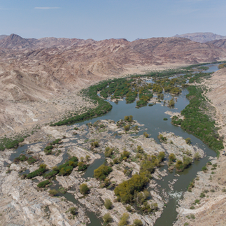
The middle Orange River lies between Van Der Kloof Dam and the Augrabies Falls. Given that the river is located downstream of hydro-electric generating impoundments the river in this section is subjected to extreme flow variation in the form of hydropeaking.
The impact of hydropeaking on the ecology of the Orange River is poorly understood. Based on personal observations, stranding of Labeo capensis and Labeobarbus aeneus was frequent downstream of the Van Der Kloof Dam in the summer periods.
THe Lower Orange RIver
This will be covered in an updated post.


Comments